


La Rivière St sauveur

Laurent53
User
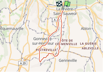

Length
12.2 km

Max alt
124 m

Uphill gradient
203 m
Km-Effort
14.9 km

Min alt
4 m

Downhill gradient
202 m
Boucle
Yes
Creation date :
2025-02-16 16:59:20.48
Updated on :
2025-02-16 17:01:00.739
3h22
Difficulty : Easy

FREE GPS app for hiking
 SityTrail
IGN / Geographical institutes
SityTrail Plus
The world is yours!
About
Trail On foot of 12.2 km to be discovered at Normandy, Calvados, La Rivière-Saint-Sauveur. This trail is proposed by Laurent53.
Positioning
Country:
France
Region :
Normandy
Department/Province :
Calvados
Municipality :
La Rivière-Saint-Sauveur
Location:
Unknown
Start:(Dec)
Start:(UTM)
301931 ; 5476452 (31U) N.
Comments
